Đăng ký bộ dự đoán đề thi IELTS, Sách/Tài liệu/Khóa học IELTS: LINK
Bài viết mẫu IELTS – The development of the village of Chorleywood – IELTS Task 1: Map
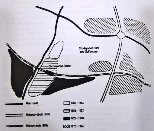
The map shows the development of the village of Chorleywood. Summarise the information by selecting and reporting the main features, and make comparation where relevant.
The map tells us how the village of Chorleywood developed between the gears 1868 and 1994. In the gears between 1868 and 1883, the village was located a small area near what is nowadays a main road running from north to south. From the gear 1883 until the gear 1922, the area south of the original village became developed along that road. This development took place at about the same time as the construction of a railway line running from east to west through the newly- developed part of the village and the Opening of a railway station to serve the village. From 1922 to 1970, the village grew south of the railway line on both sides of the existing village. A motorway running parallel with the main road and to the east of the village opened in 1970. In the period from 1970 to 1994, new parts of the village have been developed on five plots of land near the motorway. Three are near where the motorway crosses the railway and two are along a main road that connects the motorway with the main road running through the original location of the village. The area lying between the main roads, the motorway and the railway are mostly taken up by Chorleywood Park and Golf course.
Tìm kiếm chủ đề khác: dự đoán ielts speaking part 1, IELTS Speaking Part 3, IELTS Speaking Part 2
Đăng ký bộ dự đoán đề thi IELTS, Sách/tài liệu IELTS: LINK ĐĂNG KÝ